Labels

Thursday, February 21, 2019

Which Kieran?

The Gaelic language is somewhat "fluid" in its pronunciations.  Seemingly, it is unrelated to the letter combinations assembled to spell any particular word in Gaelic. 

On our return trip to Argyll in 2018, we discovered a wide variance in pronunciation between residents of the various Gaelic Hebridean islands, and among locals in west Scotland as well.  Take, for example, a seemingly straightforward word like "Ledaig".  Ledaig, of course, is an exceedingly fine Islands scotch crafted in Tobermory, on the Isle of Mull).


March 2018  Tobermory Distillery
Trying to order Ledaig at dinner, however, was something of an uncertain linguistic contortion...one that almost devolved to the crudeness of pointing rather than speaking.  As it turned out, Ledaig is subject to vastly different soundings, everything from "Led-egg" (as it is pronounced in Oban, Scotland)...to "Leet-chig" (as islanders on Mull say it).

Impassioned assurances from various regional Gaelic people, that they themselves pronounce this or that word correctly versus all those "others" in Gaeldom who do not, was somewhat a tap-in-the-ribs type of humor, albeit good-natured.  Even so, how they understand each other is a mystery.   

These introductory comments on "fluid" Gaelic spellings and pronunciations are applicable to Kilchiaran chapel. Reconciling the chapel's namesake saint is also quite an exercise.  Variously known as:  Chiaran, Ciaron, Ceran, Kieran, Kyran, Queran and more besides, the identity the specific saint is tricky.

Kieran was apparently a very popular name among early Irish saints...a dozen or more have the name.  And several are alleged to be contemporaries.  Case in point is St. Kieran the Elder and St. Kieran the Younger.

Kilchiaran Chapel on Islay is presumed to have been named for one of these two Kierans.  And most accept Kieran the Younger as the namesake saint.  But that is not entirely certain.

"Historical" accounts (the few that exist) actually commingle the lives of these two saints.  For example, Life of St. Kiaran (The Elder) of Seir translated in 1895 from earlier Irish accounts records these two saints together, with St. Patrick as well.

But if true, given the timeline broadly attached to Kieran the Elder, that necessarily would have made him very advanced in age at the time of his death, accounts imply he was born in 402 A.D. and is generally thought to have died in 527 A.D.  In contrast, most accounts claim Kieran the Younger died at a comparatively young 30 years of age. Considered to be a contemporary friend of St. Columba, Kieran the Younger's lifespan is roughly bracketed from about 516 to 550 A.D.

A few accounts (likely mistaken, having been compiled several centuries after) claim Kieran the Younger died in the "Yellow Plague".  This is mentioned because a century (+/-) difference in dating these two saints (and many others in this period) may exist.  Their lifespans are difficult to reconcile because error has been introduced due to the expanse of time (a few centuries) between the lives and the medieval writers who later chronicled them. 

Yellow fever was not introduced into the British Isles until 664 A.D.--a full century after St. Columba founded Iona, the mother church of Scotland.  The date is fairly precise, because it occurred after a solar eclipse in May of 664.  Yellow fever continued to extract an extremely high mortality toll in the British Isles for more than two decades.  Thus, it would have been a widely known historical event to the  later medieval biographers who sought to chronicle the lives of the early Irish saints.

This 20 or 25 year outbreak of yellow fever actually did kill off most of the Irish monastic community of Clonmacnoise (which Kieran the Younger is credited with establishing).  And thus, the error is understandable in retrospect.

Accounts commingle the lives of the two St. Kierans/ 
Again, no one quite certain which Kieran in whose honor the Kilchiaran chapel was named.  Whether or not they were actually contemporaries, cannot be ascertained.  But what is generally accepted is that the original Kilchiaran chapel on Islay was established at a very early date in the history of the evangelizing of the Isles and Scotland.

A last observation from the Life of St. Kieran the Elder is entirely speculative on my part.  And it is a wild speculation that I have not seen in academic print anywhere.

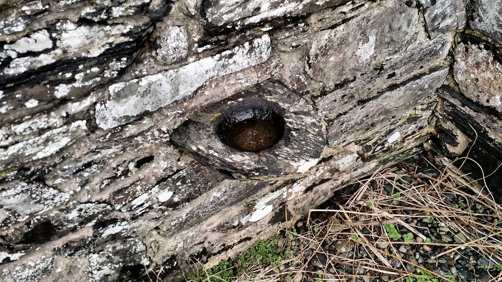
At Kilchiaran chapel is found what is called a "cup-marked stone".  It is recumbent and considered to be "earth fast"...being in the same place it was when the cups were marked.  Cup marked stones exist widely over west Scotland, some dating fairly deeply in the Mesolithic Age, to perhaps as late as the Bronze Age.  They were used in religious rites, of some sort, possibly grinding botanical compounds or grains.  No one is certain, but these cup marked stone rites were probably on the order of prayers of hope and supplication, as practiced (previously mentioned in a post here) at Kilchoman...in a relict social practice originating from time immemorial. 

The ancient graveyard at Kilchiaran is laid around this cup marked stone.  Thus, the site on Kilchiaran Bay has been long revered and recognized, perhaps several thousands of years before the Kilchiaran chapel was established, allegedly by St. Columba.  Many, and perhaps most, early Christian chapels were established on sites that were known to be sacred to prehistoric people. 


In any case, the cup marks on the stone, bear some resemblance to the constellation Orion.  Whether or not that is significant, is unknown.  (It was mentioned in a previous post on Finlaggan that the Cnoc Seannda standing stone apparently marks the rise of the constellation Orion in mid winter.)

My wild speculation takes into consideration a curious account found in the Life of St. Kieran the Elder.  The account, with an imagination, may actually relate to the cup marked stone at Kilchiaran.

A reference to the cup marked stone a Kilchiaran perhaps?

The account mentions Sancta Coinche, who is called St. Kieran the Elder's "nurse".  In modern terms, Coinche would have been Kieran's foster mother.  According to the account, Coinche used a big stone "to practice imploration and prayers".

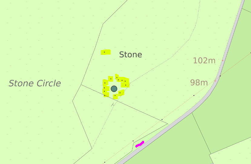
That stone, was "at some distance from the monastery on the strand of the sea"...which more or less does describe the cup marked stone at Kilchiaran Bay on Islay, if one takes strand to mean a beach.  The cup marked stone at Kilchiaran is lying on a raised shingled beach, below but included within the chapel's burial ground.

From Canmore; location of cup marked stone at Kilchiaran
Rev. D.B. Mulcahy, the translator of the 1895 copy of the Life of St. Kiaran (The Elder) of Seir, stated in his notes that Coinche's Rock is not known, at least by that name, in Ireland where the accounts of Kieran the Elder's biography supposedly occur .

He stated that Coinche's Rock was to be found on the banks of the Fergus River near Ennis in County Clare, Ireland.  What Rev. Mulcahy did not say is that he had located this rock, or had seen it.

At Ennis, a Franciscan friary did exist; but this was first built c. 1250 A.D., easily some 700 years after either of either of the Saints Kieran.

Rev. Mulcahy suggested the specific location of Coinche's Rock was at Cuinche, which today is known as the village of Quin.  An abbey also existed at Quin; but its construction began in 1402 A.D. at the request of the Franciscan abbots at nearby Ennis.

Whether or not a tradition regarding Coinche's Rock was subsequently established at these mid and late medieval monastic communities, is not known.  No evidence of any reference is known to me (other than Rev Mulcahy's translation notes) of the existence of Coinche's Rock at Quin.  Perhaps jaded, but surely if Coinche's Rock did exit there, it would have long ago been advertised.   Pilgrimages were, and are, big business to local economies.

Rev. Mulcahy noted that writers have made "a medley of mistakes regarding the nurse, St. Coinche, and her place".  Many presume that Coinche's Rock must have been located in Ireland.  But, could that also be mistaken?

This stone of imploration and prayers could indeed be the cup marked stone at Kilchiaran, at some distance from the monastery on a strand of the sea, just across the Irish Channel.

March 23, 2017  Kilchiaran Bay, Islay

Tuesday, February 5, 2019

Guidance--an old white horse

 
Inside Kilchiaran chapel ruin is found what is perhaps its most well known artifact--the Font Stone.  The Font Stone is thought to be of late medieval date (c. 1300 to 1500 A.D.)

Thus, the Font Stone was likely added to the chapel's "furnishings" a hundred years or so after Kilchiaran was constructed.

March 23, 2017  Kilchiaran's Font; surface panels separated by carved ribs (seen left on basin) 
Baptism is the sacramental rite that admits someone into the Christian Church.  Because the Font holds the Holy Water, it is therefore a central feature to the life of the Christian community whom the chapel serves.  Fonts generally are prominently placed in the western portion of a church or chapel where the parishioners entered and congregate.  The Font at Kilchiaran would have been considered a sacred vessel.

Less so today, unfortunately.

I had intended to refrain from commenting on this.  But it should be said, by way of complaint.  At the time of our visit, the interior of the Kilchiaran chapel ruin was somewhat a latrine, littered with non-buried toilet paper.  The chapel's partially reconstructed walls do provide sheltered privacy perhaps; and there is no other screened place.

Even so, a sense of sacrilege protests against such abuse.  Worse still is the matter of public health.  We urge our Illeach friends to consider installing a public facility at Kilchiaran Bay.  After all, Kilchiaran Bay is the only beach in the area.  Further, the bay is protected from the North Atlantic, which makes Kilchiaran just about the only beach on the west Rinns suitable for swimming given strong cold ocean rip currents elsewhere.  Kilchiaran is far too serene a place to permit continued defilement.


March 23, 2017  Kilchiaran chapel's Font, grave slabs, reconstructed walls and the Bay

The Font Stone itself is damaged, or rather, its rim has been chipped or broken off in places.  All in all, considering the antiquity of this carved stone basin, it is in a fairly good state of preservation.

According to Canmore, the pedestal upon which Kilkchiaran's Font Stone currently rests is of modern construction.  That probably implies that the Font Stone was raised and set upon its new base at the same time as the repairs and restorations to Kilchiaran chapel in 1972-1973.

This carved stone basin is of considerable size and weight.  In terms of its capacity, the inside diameter of the Font Stone measures about 1 1/2 feet.  Its approximate depth is 10 inches, though the rim has been reduced by damage.  The Font Stone is capable of holding a little over ten gallons.

As for the rim damage on the Font Stone, that appears to have occurred long ago.  It is not recent in any case.  A local story (assuming it is true) may account for that damage.

The Font Stone was apparently removed from Kilchiaran, and taken by a draft team to Nereabolls (Nerabus) "with great difficulty".  Evidently, Nereabolls chapel wanted the "second hand" Font Stone for its own use.  Nereabolls is a hamlet on A847 on the east shore of Loch Indaal, about half way between Port Charlotte and Portnahaven.

No date is given for the alleged removal of the Font Stone from Kilchiaran to Nereabolls; but logic would suggest that it would only have been moved after Kilchiaran chapel was already abandoned, sometime in the 1700s, about the time of the American Revolution.

The Nereabolls chapel was itself a late medieval building, c. 14th or 15th century, definitely well after Kilchiaran was built.  Little is known about its history beyond that is was considered part of the territory of the Derry, Ireland Benedictine monastery in the 15th century.

The local story claims that as long as the Font Stone remained at Nereabolls, its people had neither health or peace.  So to ensure it, they returned the Font Stone to Kichiaran, dragged back to its home by one old white horse.

March 23, 2017  Kilchiaran, north wall
The Font Stone probably was used in non-immersive Baptisms, such as those by aspersion (sprinkling) or infant Baptisms by affusion (pouring).

Aspersion is practiced in the Roman Catholic Church at Easter.  It is to remind congregants of their Baptisms and Christian vows.  [However, the Church only considers an aspersion Baptism to be valid if water flows from the skin.]

A word or two of "guidance" upon Baptism:

Denominational differences and doctrinal disputes exist that are too often unnecessarily divisive, and fought more over style than anything substantive.  I do not mention Baptism techniques to ignite internecine denominational disputes over what "the" legitimate form of the Christian rite of Baptism ought to be; but rather to describe the importance of the Font Stone to Kilchirarn's ancient Christian community.

Besides, all Baptisms are conveyed in the name of the Father, and of the Son, and of the Holy Spirit. Unless that is true, there can be no Baptism...by whatever means.

March 23, 2017  Kilchiaran Font Stone
Builders can also unwisely reject a cornerstone.  For example, the Didache (written before 100 A.D.) was set aside by the later Roman Catholic Church as non-canonical, even though the Didache is possibly the earliest Christian doctrinal text known, and even though it was accepted by the Ethiopian Church (which itself was among the earliest of all churches).

The conversation between the Ethiopian eunuch and Philip on the road to Gaza (Acts, Chapter 8) remains appropriate when considering the conveyance of Baptism, which I personally hold to be common among all Christians, by whichever method.  Only the "why" is relevant.

When Philip came up to the Ethiopian's chariot, he heard the Ethiopian reading from Isaiah.  Philip asked if the Ethiopian understood what he was reading.  "How can I, unless someone guide me?" was the reply.

To meet necessary guidance, the Didache set forth a catechism (or summary) of the principles of Christian religious practices, to instruct early Gentile Christian converts.  It noted that the preferred procedure for Baptism is by immersion in "living waters"--which is to say a flowing stream.  But the Didache also recognized circumstances where that may not be possible.  It therefore set out procedures for Baptism in those circumstances.

The simple and guileless question by the Ethiopian eunuch to Philip is relevant:  "Look!  Here is water!  What is to prevent me from being baptized?" 

At Kilchiaran, the proper answer would be "Nothing."

Within the ruined east chancel, its piscina still holds water next to the altar.  Its Font Stone, to the west, has been returned.  Outside the chapel ruin is Abhainn na Braghad (Braid), the living waters of a bubbling brook that issues over the shingled beach into Kilchiaran Bay, the only beach in the area where swimming in the cold Atlantic is safely possible.

March 23, 2017  Gleann nan Cuilean waterfall, at Kilkchiaran chapel
And above Kilchiaran are the cascade falls of Gleann nan Cuilean (The Darling Glen).  There is  nothing to separate you at Kilchiaran.  It is whole.  Entire.  One.

March 23, 2017 A placid Kilchiaran Bay


Monday, February 4, 2019

Ablution at the bay

In 1972-1973, the Kilchiaran chapel ruin that is seen today is the result of a partial restoration by the Islay Historical Buildings Works Group.

March 23, 2017  Kilkiaran Chapel ruin on Islay
However, the east gable end (the tallest part of the ruin) was "original" at least to the medieval chapel building.  As the case with many medieval chapels, Kilchiaran likely was placed over an even earlier edifice.

Ignoring some lower wall foundations from the medieval construction (none exceeding three feet in height) in the nave of the chapel, the chancel section of the chapel (where its altar was located) was essentially the only part of the medieval structure still standing.

March 23, 2017  "New" east gable burial ground at Kilkiaran; single track visible on left.

Outside the chapel's east gable, a walled small burial ground was added (in the 1700s).  It was abutted against the outside of the chapel's eastern wall.  It is possible that the work to build this "new" walled cemetery ultimately helped to shore up or stabilize the east gable, fortifying its foundation.

Kilchiaran was apparently still in use when Martin Martin, a Gaelic speaking geographer, visited Scotland's "Western Isles."  He listed it as one of two parish churches on the Rinns when he visited in the 1690s.  But by 1794, roughly contemporary with the "new" cemetery on the east gable, Kilchiaran was reportedly roofless.  It has been open to the elements and deterioration for over 200 years.

The interior side of the east gable has several architectural features of interest.

March 23, 2017  Interior, Kilchiaran Chapel chancel, the east gable
Excavations at the time of the 1972-1973 repairs indicated that the chancel was  built about two feet higher than the nave of the chapel, where the parishioners congregated.  Apparently, this "mezzanine" was the original design of the medieval chancel. Two wide stone steps centered below the altar allowed access to the chancel and altar.  The east gable wall was therefore integral to Kilchiaran's chancel.

Three ambries, one low and two larger in the middle of the gable wall behind the altar, are also considered original to the medieval construction.  In common use during medieval times, these ambries would have probably been painted.  For those needing a fresher on Christian rites, an ambry is a recess built into the wall of a church for holding sacred vessels, books and  vestments.

March 23, 2017  Three ambries in Kilchiaran chapel chancel wall
Excavations at the time of the repairs uncovered the masonry remains of the altar.  The stone altar now seen at Kilchiaran dates to the 1972-1973 restorations.

March 23, 2017  Reconstructed altar in Kilchiaran chapel; basin stone slab in wall to right
It is "presumed" that medieval grave slabs now located in the interior of the chapel were moved from the burial ground and placed there at the time of the early 1970s repair work.

March 23, 2017 Effigy of a n unknown cleric
This "presumption" is somewhat surprising.  One would think that any such major modifications to the  ancient burial ground would have been recorded, certainly by the time 1970s archaeology work was being done.  That would have been well into the scientific era of archaeology with its academic regimen.  Perhaps those records exist in archives.

Existence of a burial aisle in the medieval chapel building is uncertain; early descriptions of the place at least do not say so. Thus, the burial slabs are presumed to have been placed within the ruin's reconstructed walls during the 1970s repair work.

Moving the grave slabs to the protection of the chapel's walls was probably a well intended gesture.  One account claimed that a substantial part of the chapel's ancient burial ground was obliterated when the single track road was constructed just above Kilchiaran Bay.

March 23, 2017 Dirt track through Kilchiaran's old burial grounds
Further loss has occurred due to river erosion, and a dirt track now runs through part of the old burial ground as well.


Lastly, perhaps the most interesting architectural feature on the east gable wall is a shallow basin stone, of some sort, built into the wall's masonry.  A quandary of sorts.

It has been suggested that this might be a piscina--a shallow basin placed near the altar (as this one is) and used for washing Communion vessels.  If the shallow basin stone at Kilchiaran is a piscina, it would be an early example of one.

Washing (or purifying) sacramental vessels and hands in Christian practice is known as "liturgical ablution"  For this purpose, piscinae typically have a drain--called a sacrarium--by which sacramental waters (or "particles") are ceremonially returned directly to the Earth.

The basin stone built into the east gable at Kilchiaran has no drain.  For some, this fact gives pause in defining it.  Of course, lack of a drain does not exclude the basin stone from being a piscina.  In fact, the first examples of piscinae were mere cups.  Later, small basin stones  (like the Kilchiaran example) served the sacred purpose.  These were typically placed close to the wall near the altar.

March 23, 2017  Basin stone in Kilchiaran's east gable interior wall
Later still, piscinae were built into sanctuary walls; and by this time (1300s) piscinae usually included a sacrarium and they were also usually built into ambry recesses as well, being considered a sacred object in itself.  Thus, later medieval picscinae would typically have been recessed versus protruding, as in the case of the basin stone at Kilchiaran.  The ambries that do exist at Kilchiaran were not built to contain a piscina.

Rarely were piscinae found in Britain until perhaps the mid 13th century.  This leads to the obvious question:  "So, when was the medieval Kilchiaran chapel built?"  Unfortunately, once again the answer is "uncertain".  Most scholars consider Kilchiaran to have been built during the 13th to 14th centuries.  Some are more precise, estimating Kilchiaran was built in the early 1200s.

Given the "primitiveness" of the basin stone at Kilchiaran, if it is indeed a piscina, then it would be certainly be in agreement with an early 1200s estimated date of construction.  The corollary is that this same "primitiveness" probably does not support a late 14th century construction date, since by that time, liturgical ablution was widely common in Christian communities, using more "refined" piscinae.  The basin stone at Kilchiaran chapel is hardly sophisticated.  It is relatively crude.

New archaeological estimates (the 2003 Coastal Zone Assessment Survey of Islay) have expanded the date range for the existing medieval "fabric" at Kilchiaran.  Estimates have moved forward by a couple centuries, dating the possible construction of Kilchiaran chapel from sometime between the 10th and 14th centuries (900s to 1300s A.D.).  This increases the uncertainty.  By this estimate, the medieval ruins at Kilchiaran could be as early as the 900s A.D....a very aggressive estimate

March 23, 2017  Nave entrance and probable window, as conceived in 1973 repairs 
Lastly, regarding the basin stone in the east gable wall, an alternative purpose for the basin stone at Kilchiaran has been suggested; namely, that it is lamp stone.  According to that theory, it would have been filled with oil or fats, with a floating wick for illumination.  Though plausible, a lamp seems unlikely.  Further, if one assumes the present altar was reconstructed to the correct height during the 1972-1973 repairs, light from the hypothesized lamp would have been somewhat below the altar top.

The modern suggestion of a lamp is at variance from what early geographers visiting the site considered it to be--Muir (1855) and Graham (1895).  Graham stated "to the right of where the altar stood, there is a projecting stone hollowed into a little basin as if for holy water."

For what it's worth, this traveler also agrees with the earlier view, that it is a "primitive" piscina.  This suggest the medieval Kilchiaran chapel was probably built in the early 1200s over an even earlier chapel on the site, as has been true for many and perhaps most medieval chapels in Argyll & Bute. 

March 23, 2017  Kilchiaran grave stones


Sunday, February 3, 2019

Anatomy at the water's edge

Connected to Cultoon stone circle along the "minor" road on west Rinns is Kilchiaran Bay, where the single track bends east back to Port Charlotte and the Loch Indaal.

March 23, 2017 Kilkiaran Bay at the water's edge
Generally, we were always within sight of the ocean during our 2017 tour of Islay. Even so, among Darla's few adamant requests in our 2017 itinerary (another being a shopping visit to Islay Woolen Mill) was a walk along the sea coast, to spend meditative time at the water's edge.

"To touch the ocean," as she called it.

March 23, 2017 Kilkiaran Bay
During the winter months in Idaho leading up to our Easter 2017 trip, we armed ourselves with Ordnance Survey maps, a calendar and a list of sites to see. We considered walks on the shore at Sanaigmore, Saligo, Lossit Bay and even at Machir Bay. They each had merits.

March 23, 2017 Kilkiaran Bay; road cut visible just above bay at utility line
We settled on Kilchiaran. Logistically, it was the easiest to access, lying directly on the single track from Portnahaven just north of Cultoon stone circle.
March 23, 2017 Kilkiaran chapel on Abhainn na Braghad

As an inducement, we were also intrigued by Kilchiaran chapel ruin; it is locally alleged that St. Columba first set foot on Islay here in ~650 A.D. The chapel ruin stands at the head of Kilkiaran Bay on Abhainn na Braghad, a stone's throw below the single track.

To decipher the Gaelic place name again requires consulting Dwelly's Gaelic dictionary. Not being a linguist (and certainly not conversant in Gaelic), I can only make a stab at translating "Abhainn na Braghad".

In this, I admit an eccentric interest. Perhaps it is the romantic in me, but Gaelic is a poetic language. It has a sonic beauty, a soft roundness. It almost sings, evoking myth and mystique.

Once nearly extinct, Gaelic is an ancient tongue spoken in a bygone age of knights and damsels, bards and ascetic hermit priests, fairies and magicians. My translations attempt to provide a cultural richness, an esoteric understanding.

Self revelations aside, "Abhainn" is a common Gaelic geographical term in Argyll.

Its meaning becomes obvious, once one consults enough Ordnance Surveys.


Abhainn means river, or more precisely "stream".

The trickier Gaelic translation is "Braghad". It generally means neck, or throat, or upper chest. But in this particular place name, Braghad probably is a specific reference to the hollow in the upper part of the breast, roughly at the sternum.


Admittedly "Sternum Stream" is hardly romantic. As a geographic and anatomical description however, it is comparatively accurate.

Apparently it refers to the shape of the stream valley, when viewed from the water's edge as Abhainn na Braghad empties into the headland of Kilkiaran Bay and drains over the shingle beach into the Atlantic.

A picture being worth many words, the following photo looks up Abhainn na Braghad toward Kilkiaran chapel ruin. It shows the "U" shaped rocky ribbed outlet.
March 23, 2017 Abhainn na Braghad and Kilkiaran chapel ruin
An anatomical drawing (snipped from healthline.com) compared to the rocky skyline as Abhainn na Braghad opens to the Kilkiaran Bay headland looks remarkably similar.


A note:  The Ordnance Survey has Abhainn na Braid.  So a difference, depending on whether a surveyor or an archaeologist are describing it.  Braid is essentially synonymous with Braghad.  Braid means horse collar.  Locally on Islay Braid it also takes on the meaning of the collar on a thief's neck...the metal shackle collar.

These describe the same feature...the hollow in the neck or at the collar.  However, for completeness this from Dwelly's Gaelic Dictionary (Illustrated):


Friday, February 1, 2019

Unfinished


After an extemporaneous visit to the "new" Celtic Cross monument at Port Weymss (commemorating the sacrifice of local men during World War Two), we headed into the heart of Islay's Rinns for a day of exploration.  Once more, our exploring took us off Islay's main road network.  We took the north-south single track from Portnahaven to Kilkiaran Bay.


March 23, 2017  Portnahaven single track; south of Kilkiaran Bay


The name for this "minor" road is not known.  For our purposes, the "Kilkiaran Road" will have to work.  Other than the A847 on the east shore of the Rinns along Loch Indaal, the single track "Kilkiaran Road" from Portnahaven is the only vehicular route on the Rinns.  Skirting Islay's western seaboard, it runs parallel to the main A847 road from Port Charlotte to Portnahaven.

March 23, 2017  Kilkiaran Bay one of the few natural ports on west Rinns

The northbound Portnahaven single track turns east at Kilkiaran Bay.  At this point, the single track is apparently called "Schoolhouse Road".  It runs to Port Charlotte where it links up with the main A847.  The west side Portnahaven-Kilkiaran single track when combined with the A847 provides a less traveled and scenic loop route on the southern half of the Rinns for those tourists interested in such explorations that lie beyond the scotch distilleries of Islay.
   
March 23, 2017  Port Charlotte
The west side single track also serves as a Scriptural metaphor, in a fashion.

In its construction, local ambition wanted to punch the single track through the Rinns all the way to Kilchoman, and thus provide an uninterrupted link along the island's west side, a continuous north-south direct single track from Portnahaven to the  Kilchoman Parish Church.  But the through route was not be.

The single track was not completed north of Kilkiaran Bay due to difficult terrain in the Rinns, a shortfall of money and other competing priorities which intervened. Here the Scriptural metaphor recalls the parable from Luke 14:28-29 regarding unfinished constructions.

That metaphor is also appropriate for a site that we had earmarked on our 2017 Islay itinerary as a  "must see"--the Cultoon "stone circle".  Cultoon lies on the unfinished "Kilkiaran Road".  The stone circle too had been started, in its case untold ages ago.  And it too was never completed.

Advise using Car Park since high tensile fence lacks direct access at gate to Cultoon circle
We had already visited the lone standing stone (Mesolithic Age) on Cnoc Seannda the day before making our excursion to the Rinns.  But, that standing stone was viewed in the context of our tour of Finlaggan.  Cultoon would be our first look at an actual "Stone Age" construction project.  We were excited about the prospect.

March 23, 2017 Wide lens view of the unfinished Cultoon Stone Circle

Work on the Cultoon stone circle has been arrested in time. Differing by degrees, perhaps, but Islay's peat which covered the Cultoon circle was similar in its preservation as was the more infamous volcanic ash that covered Pompeii (Mount Vesuvius eruption in 79 A.D.).

While many archeological sites in west Scotland have not been excavated, Cultoon's stone circle was formally investigated in the mid-1970s by Euan MacKie.  Because the site was essentially peat covered, MacKie considered the Cultoon excavation as a "blind test" of Scottish engineer Alexander Thom's hypothesized "Megalithic yard" in use during Stone Age construction.

March 23, 2017  One of two visible standing stones (~east) at Cultoon Stone Circle
Until the site was systematically excavated, it had been assumed that the recumbent megaliths at Cultoon had simply fallen over in the thousands of years since they were erected.  MacKie's excavation sought to identify those original locations and "restore" the recumbent standing stones to their former sockets.  In other words, stand the circle up again.  But the excavation uncovered something else entirely.

March 23, 2017  Cultoon's second visible standing stone (~west); rock cairn bank (foreground)


To the degree possible these many thousands of years later, Cultoon's story is now partially known.  This is not to say that significant scholastic disagreement does not exist.

The original plan at Cultoon apparently was an ellipse with 15 standing stones.  Three standing stones were actually erected, two of which two are visible and upright.  One was a broken stump of a standing stone, revealed only by the excavation work...after removing the peat layer above it.


March 23, 2017 High tensile fence right on the edge of Cultoon circle

Twelve stones of considerable size were apparently intended to be raised as standing stones in the circle.  But these remained prone on the old ground surface, after having been dragged to the Cultoon site many thousands of years ago.  These megaliths were more or less positioned on the former solid ground surface into a rough ellipse, apparently in preparation for their installation into socket pits in an ellipse of standing stones. 


March 23, 2017  Prone megaliths at Cultoon, with one of two standing stones (~west) visible

Socket pits had indeed been dug into the old ground surface...for some of the planned standing stones.  Five sockets with corresponding stones remained empty, never receiving their standing stone.  And even the socket hole digging part of the project was incomplete.  Some stones apparently never had sockets dug at all. And the dragging of megaliths to the site was also unfinished, since some socket holes (nine total) were dug but which lacked a corresponding stone. 

For unknown reasons, the Cultoon stone circle was abandoned, right in the middle of its construction.

March 23, 2017  Cultoon stone circle terrain

Over time, the abandoned open socket pits silted over.  One open socket, however, was deliberately  filled, apparently at the time Cultoon was abandoned.

Megaliths intended for standing stones in the planned Cultoon circle were simply left where they laid on the old ground surface...and this is key.  The archeological time boundary is the old original surface, directly underneath the stones that had been dragged to the Cultoon site.

The peat which today covers much of the Hebrides has not always been there.  In fact, at the time the Cultoon circle was being constructed, the ground was solid with a soil profile. The large megaliths therefore lay in direct contact with that older ground surface.  Then, in time, the old ground surface and the prostrate megaliths were subsequently covered (or partially covered) by a meter or deeper layer of peat, in situ.

During the formal excavation at Cultoon, Carbon 14 dating indicated that peat did not begin to cover the site until after approximately 765 B.C., roughly concurrent with the transition period between the Bronze Age and the Iron Age.  Thus, the Cultoon stone circle had to date at least some considerable time before this cultural boundary.  Besides, megalithic constructions of standing stones and circles had more or less culturally ceased by the close of the Bronze Age [c. 2100 B.C. to 750 B.C]  throughout Scotland, as the interests of human society changed.

March 23, 2017  Two prone megaliths at Cultoon circle (#3 in MacKie's site plan)


Just north of the circle (considered part of the Cultoon site, though scholastic debate continues) is a single standing stone on a small hill.  Its stone socket had also been dug into the old surface before the peat encroached.  Prehistoric fires apparently had been set a number of times on the hill's old surface prior to peat encroachment.  A dense large mass of charcoal from these fires was Carbon 14 dated to the late Bronze Age, an un-calibrated date of approximately 1055 B.C.  Calibrated, the date of these fires was estimated to be (c. 1600 B.C. to 800 B.C.)


Site map of Cultoon from excavation by MacKie

The age of the Cultoon project is not known with certainty.  Canmore calls the site a Neolithic/Bronze Age monument.  However, on and in the former topsoil at Cultoon, archeologists found Mesolithic Age flint microliths, and possible votive Mesolithic flint cache offerings placed at the base of the two standing stones in the circle.

This indicates that the Cultoon site was revered (or at least in use) since Mesolithic times [c. 10,000 to 5,000 B.C.--the era during which rising seas separated Britain from Europe, and Ireland from Britain.]  Mesolithic flints are indeed known on the Rinns side of Islay, unearthed from excavations at nearby Coulererach, just north of Kilchoman.  Carbon 14 dating of charcoal from the Coulererach "occupation level" dates approximately to 5,500 B.C.

Also discovered on Cultoon's old surface and just above it, archeologists found larger flints, which they assumed were Neolithic in age [c. 4,000 to 2,000 B.C.]   Based on this sequence profile of artifacts, at least in my own novice opinion, the unfinished Cultoon stone circle is probably not later than early Neolithic, given these intermixed stone artifacts.  This suggests that the Cultoon construction project was undertaken during the approximate cultural transition between Mesolithic and Neolithic, with the understanding that early cultural ages often overlap considerably.


In the lower peat layers above Cultoon's old surface, the excavation uncovered scrapers that apparently date to the Bronze Age.  So here too, these scrapers confirm that Cultoon had already begun to be wrapped in a layer of peat by the time of the Bronze Age.  Furthermore, Cultoon's standing stone sockets had already been silted up by that time as well.

Culturally (and approximately concurrent with the advance of peat at Cultoon) by the end of the Bronze Age, stone circle constructions had ceased across Europe.  Those societal construction projects were replaced by the nearly omnipresent large scale Iron Age duns (hillforts) throughout  west Scotland, perhaps indicative of an increasingly violent age. 

Why Cultoon (which must date a couple thousand years earlier than the Bronze Age) was not finished is speculative.  Warfare could have halted it, a violent raid upon the builders perhaps.  No direct evidence of conflict exists at Cultoon.  Yet, evidence might be found in what has already been excavated.  Given the intermixed Neolithic and Mesolithic artifacts unearthed on the old surface at Cultoon that could indicate that a more advanced culture (a relative term at best) supplanted the builders at Cultoon in the process of building...at the dawn of the Neolithic Age on Islay.     

Of course, it could be a host of other reasons.  Local food resources may have been insufficient to sustain what would have been a relatively large scale social organization of workers required to build the designed project at Cultoon.

But whatever reason, the unfinished Cultoon stone circle on the unfinished Kilkiaran single track road in the Rinns is a poignant metaphor, at least Scripturally.